

Ōtautahi – After an extremely wet winter for a lot of the country, MetService is forecasting changeable weather as Aotearoa heads into spring with some cooler temperatures.
August rainfall records were broken in New Plymouth, Palmerston North, Wellington (Kelburn), Blenheim, Wanaka, and Nelson (also their second wettest month at any time of year since 1941).
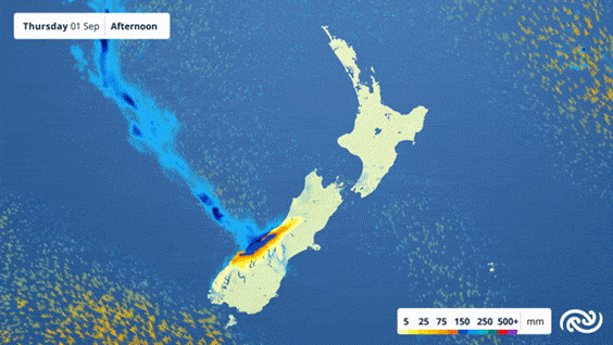
Heavy rain is currently affecting the West Coast and the main divide of the Southern Alps, where Orange Warnings are in place until early tomorrow morning. More than 100mm has already accumulated at some West Coast stations in the 24 hours up to midday yesterday, with 300-450mm still to come in some places up in the ranges.
The West Coast rain will ease to more showery weather tomorrow at the same time as a front quickly crosses the North Island with a splashing of rain and a change to cooler southwesterlies. Cooler air on the way from the south also brings a risk of snow down to 500 metres in the hills of Southland and Otago this weekend before high pressure moves in.
Temperatures are on a downward trend as the cold air spreads northwards, starting in the South Island where widespread frosts are forecast from Sunday morning heading into next week.
MetService meteorologist Dan Corrigan says Gore and Invercargill are looking at a high of only 8°C on Sunday with blustery westerlies, and most South Island towns will struggle to reach double digits in the afternoons early next week.
Meanwhile at the opposite end of the country, a low pressure system is forecast to cross the upper North Island during the second half of Monday.
Monday’s low pressure system is likely to bring a burst of heavy rain and strong easterly winds, though current data suggests it will move away to the southeast relatively quickly. We recommend people keep an eye on our website or app for any severe weather forecasts that may be issued closer to the time.
The Metservice’s severe weather watches and warnings:
Outlooks are about looking ahead:
• To provide advanced information on possible future Watches and/or Warnings
• Issued routinely once or twice a day
• Recommendation: Plan
Watches are about being alert:
• When severe weather is possible, but not sufficiently imminent or certain for a warning to be issued
• Typically issued 1 – 3 days in advance of potential severe weather.
• During a Watch: Stay alert
Orange Warnings are about taking action:
• When severe weather is imminent or is occurring
• Typically issued 1 – 3 days in advance of potential severe weather
• In the event of an Orange Warning: Take action
Red Warnings are about taking immediate action:
• When extremely severe weather is imminent or is occurring
• Issued when an event is expected to be among the worst that we get – it will have significant impact and it is possible that a lot of people will be affected
In the event of a Red Warning: Act now.